|
|
| • Origin of Name |
 |
In 1454, Masamichi Kawano of the local Tsugaru area ruling family built a chateau (tate) at the fishing village called Usukeshi (meaning the edge of the bay in the native Ainu language) during the Muromachi Period (1336 - 1573). As it had a box-like shape (hako), the chateau would come to be known as Hakodate. Today, the remnants of this chateau can be found at the top of Motoizaka Avenue.
In 1869, Ezo was changed to Hokkaido, while the first character in Hakodate ( ) was modified to ( ) was modified to ( ) as it appears today. ) as it appears today.
|
| • Geographical Features |
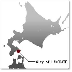
Located at the southeastern corner of the Oshima Peninsula, Hakodate is surrounded by the Pacific Ocean and the Tsugaru Straits to its east, south and north and bordered to the west by the city of Hokuto, Nanae Town, and Shikabe Town.
|
 |
|
| |
| • Land Area |
677.92 sq. km (as of Oct. 1 2008)
|
| • Location |
140 degrees 44 minutes East Longitude, 41 degrees 46 minutes North Latitude (Hakodate City Hall)
|
| • Map |
View Hakodate City Hall in a larger map
|
|
| |
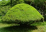
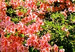
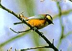
| • Hakodate City Tree, Flower, Bird, Fish |
· City Tree
Japanese Yew
(instituted April 1 1975) |
· City Flower
Kaempfer Azalea (Yama Tsutsuji)
(instituted April 1 1975) |
· City Bird
Varied Tit
(instituted May 10 1987) |
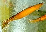
· City Fish
Cuttlefish
(instituted August 1 1989) |
 |
 |
 |
 |
|
|
|
|
| |
|
|